

Rita
WALKING WITH BATHOLOMEW
It is said that if you stood in Hungerford High Street and threw a stone in any direction that it would land in the countryside that surrounds our town. Although I would not recommend this, as it might upset the local wildlife this statement is very true. We are surrounded by some of the most beautiful countryside in Southern England. From the bleakness of Salisbury Plain to the rolling beauty of the Marlborough Downs, from the mysteries of the Savernake Forest to the poetry of Richard Jefferies Liddington Hill.
You might just get up one morning and head in the general direction of the countryside, with no real plan in mind and stumble across what you may and maybe research what you have seen and found on your return. I believe I have heard this referred to as free-walking. Or maybe you will use a map either physically or on-line. There are many maps on the market each very good in their own way but do you sometimes long to be just that little bit lost? Really, about half way between the worlds of free-walking and Ordinance Survey.
Well there may be an answer at hand, treat yourself to an old copy (1910-1925) of a Bartholomew’s Half-Inch Map covering the area you wish to explore. Bartholomew’s a familiar name but you cannot just put your finger on who they are and where to purchase them. Well if you want an up to date Bartholomew’s map then they are still available although now to be found as a trade name under the banner of HarperCollins (Collins Bartholomew). But that is not so much fun; modern maps maybe provide too much information and remove the romance of walking a little. Sometimes you want to look at that mysterious mound in the meadow and wonder at its past and not be informed that it was just spoil from the latest by-pass.
But what of Bartholomew’s who are they and why is the name imprinted on the consciousness of anybody born prior to the nineteen-seventies? Well the answer is to be found many miles from Hungerford, in Scotland.
 It all started with a George Bartholomew (1784-1871) who worked as an engraver in Edinburgh and started the cartographic dynasty. His son John Bartholomew Senior (1805-1861) founded the Bartholomew company in about 1826 and twenty years later he produced the memorable General Atlas of 1846. Another two John’s, John Bartholomew Junior (1831-1893) and his son John George Bartholomew (1860-1920) really brought the company to prominence and soon it was publishing its own researched copies.
Later John’s also helped to cement the companies name into our memories. For the record these were John Ian Bartholomew (1890-1962) and a member of the fifth generation of the Bartholomew’s John Christopher Bartholomew (1923-2008).
Whilst the early Bartholomew’s would have been atlas’s possibly on a larger scale it was really a change in the recreational habits of the Victorians that noted the needs for more intimate maps. The Industrial Revolution had produced cloying diseased towns and cities and certain members of the population were beginning to want to explore what was left of the green and pleasant land. The bicycle was beginning to make itself felt and the ideas of Mr Marx and Mr Engels were beginning to revolutionise the way people thought and the way they worked. This said it was going to be a number of years before the average working man would be able to get up and go and explore the countryside.
If you wanted to explore parts of Scotland then by 1875 Bartholomew’s were publishing its individual folded half-inch series. In 1897 the company added the England and Wales series which were an instant success. Colour was being used to provide more detail (The Ordnance Survey maps were still using the black and white one-inch maps). These maps were very accurate and by using a larger two miles to an inch format the whole presentation was easier to read and use.
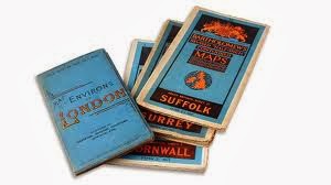
But how do you find these early maps and how do you recognise the issue. Well in some ways we are back into John Land again. The early maps from 1897 onwards were brown of cover with the beautifully unwieldy title of Reduced Ordnance Survey for Tourists and Cyclists and the area covered (Devon for instance) was noted on a printed sticker pasted over the middle of the cover. Although a little hard to see there was subtle classical feel to the cover which is very comfortable to the eye.
By 1904 the title was reduced to the New Reduced Survey for Tourists and Cyclists these covers were also blue instead of brown and the maps were cloth backed instead of made of paper as the brown 1897 ones were. This simple change of material also explains why you can quite easily find one of the Bartholomew Blues but may struggle to find a Bartholomew Brown. Although Bartholomew Blues date back to c 1904 there is evidence that the Bartholomew Browns did linger on to 1911, maybe longer.
 The early Bartholomew Blues also had advertisements noting other Bartholomew products and also a guide to the sheet numbering. If for instance you wanted to explore The Lake District then you knew which Bartholomew’s map to choose. Also as cycling became more popular then additions were added for cyclists such as hints as to the quality of the roads also the Cycling Touring Club logo appeared on these maps from 1904. Whether you were on two wheels or two legs your Bartholomew’s was becoming more and more valuable.
Quite a few of us remember the slightly later Bartholomew maps which had a more colourful cover than the 1904 editions. They were still Bartholomew Blues but there was the use of orange lettering as well as the CTC logo which was much more prominent. This new more familiar style emerged around about 1930 and lasted for a number of years before changing again and again in line with improvements in printing techniques and presentation. If you purchased a Bartholomew map in the nineteen sixties or seventies then the map you would have purchased would have been radically different to the one your father would have purchased a generation earlier.
Recently I purchased a Bartholomew map of Salisbury Plain dating from between 1910 and 1920. It is interesting to look at it. You could still reach Marlborough by railway as well as alight at a choice of two Savernake stations (High Level and Low Level) for onward exploration through the forest. The Forest Hotel (now residential) was there for your overnight comfort and although the Kennet and Avon Canal was in decline. I believe that The Bruce Tunnel that runs under the GWR was still in use.
 There was a tiny village on Salisbury Plain called Imber which had existed since before the Domesday Book which by its remoteness was mainly a village where agricultural folk lived. If you take 1920 as a benchmark then this quiet little village had only twenty three years to live as the army took it over during the war and to this day have not returned it to its rightful owners (there are open days but apart from the church and a couple of other buildings the village is derelict).
In 1920 with the help of your Bartholomew’s (and maybe the weather) you would have been able to take refreshment at the Bell Inn (I am told that the building still stands) as you travelled across the plain.
This is the beauty of my map; I can see Wiltshire and West Berkshire as the people alive at the time would have seen it. Hungerford is shown on the map and geographically has not changed much but in other parts of the area major roads and motorways have appeared. The railway network has withered (Grafton and Burbage railway station, next stop, no more) and where there were meadows there are now houses.
Villages such as South Marston (the home of Alfred Williams) and Coate (most notably connected with Richard Jefferies) were some miles from the town of Swindon and my Bartholomew’s showed this to be true. As we know today both villages are really only glorified suburbs of the town which is a little sad.
But where do you purchase these wonderful maps? Well it is easier than you might think, if you go into most middle market antiquarian bookshops then you will probably find one. Antique shops and arcades are a good point of reference and of course the internet. I was very lucky when I picked my Bartholomew’s as the first two I found were of Hampshire and Salisbury Plain. If you are looking for a specified area then you might need to search a bit.
The later Bartholomew Blues (1930 onwards) are obviously easier to find but the earlier Bartholomew’s are not that rare (although you do not see the Bartholomew Browns that often). Prices vary considerably, I picked my two up for a pound each, but I have seen them priced for more. The condition of the map also is a consideration. But I think if you are willing to pay between five and ten pounds then you should be able to pick a good Bartholomew Blue.
It is here the fun starts, pack your sandwiches, lock your children away and send your dog to a cattery. Choose your area and either catch a train to your starting point or start walking from your town. You should set yourself two rules:
 1/ Always take notice of where your Bartholomew’s takes you (unless you find the M4 or the like blocking your progress). Try to envisage where the map would have taken your grandparents.Where they would have stopped and possibly stayed, what they might have seen and heard. I have in my travels been surprised how much has not changed in this area. The barn noted in 1911 is the barn you see in 2014. The small country lane ten miles from Marlborough is still the leafy quiet country lane ten miles from Marlborough.
2/ Always take your mobile. Bartholomew is a good companion but as you must remember is advanced in years and sometimes you might just a helping hand from this modern age.
Recently I walked some twelve miles with Bartholomew towards Swindon partially using footpaths and sometimes the main road. My destination was Liddington Hill as I wanted to sit where Richard had sat some one hundred and fifty years ago. The map helped me find it easily (although I was aware of its location) and as I sat on the grass looking down I closed my eyes and thought of the description that my Bartholomew’s had given me. There was no motorway scarring the landscape at the base of the hill. All that could be heard were the birds Richard had described in his books and all that I saw that day were the meadows that Bartholomew had described as they retired quietly towards the distant town of Swindon.
Stuart Miller-Osborne


For all the latest news read our Newsletter at www.hungerfordarcade.co.uk
No comments:
Post a Comment